FMI Asia-Pacific Study Center
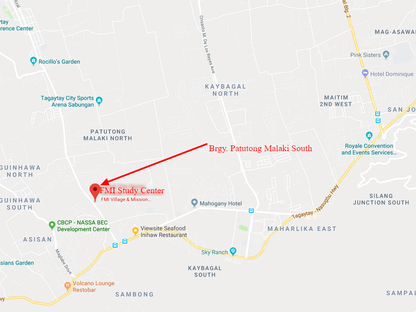
New Location: Brgy. Patutong Malaki South, Tagaytay-Mendez Road, Tagaytay 4120
Philippines Phone Numbers: Landline 046-483-0490 Cell 0942-805-2371
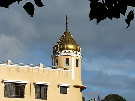
New Location: While on Aguinaldo Highway go to Crossing Mendez, proceed on the Mendez-Tagaytay Road (towards Mendez) pass Mayor's Drive then after 200 meters the Center is on the right side (light brown building with gold dome on top). Turn right up dirt road and park.
Our Location:
Geography
Tagaytay City lies on top of the Tagaytay Ridge, which, at 640 meters above sea level, is the highest point in Cavite. The ridge provides a spectacular view of Taal Lake and Taal Volcano in Batangas. This view supports Tagaytay's main industry, which is tourism.
Location
Tagaytay City is located in the Province of Cavite, on the island of Luzon, approximately 56 kilometer south of Manila. It lies within 120° 56' longitude and 14° 6' latitude and overlooks Manila Bay on the North, Taal volcano and Taal lake on the south and Laguna Bay on the east.
The City is linked by the national highway to the Metropolitan Manila Area and to the Province of Batangas. It is also connected by the roads to the adjoining municipalities of Amadeo, Mendez, Indang, Silang and Alfonso in Cavite towards the northwest, to the municipalities of Calamba and Sta. Rosa in Laguna in the northeast and to the town of Talisay in Batangas in the south.
Land area
Tagaytay City has a total land area of 65 km² which represent about 5.14% of the total area of the Province of Cavite. There are 34 barangays, 6 of which are urban and the rests are classified as rural.
Topography
Tagaytay City is characterized by mixed topography, the southern and eastern potions are covered by hills and mountains which is generally forests and open grasslands. These are the ridge with slope ranging from 10.0 to over 25 percent. On the other hand the portions adjoining the municipalities of Mendez, Indang, Amadeo and Silang are level to nearly level areas interspersed with very gently sloping surface. the built-up areas including the urban center situated in these relatively level portions of the city.
Tourism
Tagaytay's Picnic Grove, with the Taal Volcano at a distance
The city of Tagaytay is a tourist attraction for local and foreign visitors. It is an excellent vantage point of Taal Lake and Volcano. Tagaytay offers a breathtaking sight of the famous Taal Lake - a lake within an island within a lake.
Tagaytay City has vast resources and possesses tremendous potentials for development in tourism and agriculture. It is envisioned to become a city that is enrich and comfortable to live in and visit, with flowers in bloom along roadsides, ridges and mountains swathed in green, pure and unpolluted air and climate always invigorating. Tagaytay is a perfect getaway for people seeking respite from the daily pressures of life in the metropolis. It is home to more than 60 convents and congregations and numerous hotels, resorts, and convention centers. Lush forests, open grasslands and gentle slopes make up a calm scene that pleases and refreshes the eye - conducive for meditation and concentration needed during training, conventions and retreats.
Tagaytay’s three anchors of growth are tourism, agriculture and the development of the City’s institutions. The City’s inherent environmental splendor and unique rustic atmosphere, made possible by Tagaytay’s God-given natural endowments and fresh cool air, has fueled it to its present state of growth. Careful implementation of land use policies is being undertaken to protect the city’s agricultural sector. The community aims to sustain a strong ecological-tourism base with ample physical and social infrastructure system support. Tagaytay is a city in transition. There is a fundamental shift occurring in the City’s economic structure from an agro-based to a service-oriented community. The current business trend in Tagaytay is the construction of exclusive weekend residential and recreational activities.
How to get to Tagaytay?
Tagaytay is an hour and 15 minute drive from Manila via the South Luzon Expressway or using the Coastal Road Expressway and the Aguinaldo Highway. If going through the South Luzon Expressway, take the Carmona Exit and drive down through the Governor's Drive and Silang up to the entrance of Tagaytay City. Or through South Luzon Expressway, take Sta. Rosa exit going straight to Tagaytay City. There are two possible ways to get to Tagaytay via the Coastal Road: Taking the Coastal Road to the Aguinaldo Highway and continuing south, and using the Indang and Mendez Roads in the Trece Martirez and Amadeo areas. If coming from the neighboring town of Ternate, Cavite take the Naic Road and drive straight to Indang and Trece Martirez. From Batangas Province, the best way to reach Tagaytay is through the new circumferential road. From Laguna, you may enter Tagaytay through the Carmona exit. There are buses that ply to Tagaytay from Manila on a daily basis from 8:00 AM to 6:00PM. Several bus companies have their terminals in EDSA, Pasay City, and at Baclaran, below LRT, Manila.
ClimateTemperature and precipitation
Tagaytay City's climate is characterized by relatively low temperature, low humidity and abundant rainfall. The City is endowed with a cool and invigorating climate with an average temperature of 22.7 °C. Situated approximately 600 meters above sea level, the city is misty and is relatively cooler during the months of December, January and February. Like most areas in the Province of Cavite, the city has two pronounced seasons: dry from November to April and wet during the rest of the year. The climate has made the city very ideal for sports, picnics, conferences, honeymoons, country homes, and spiritual retreats.
Humidity
Tagaytay has an average humidity of 78% which makes the city cooler than Metro Manila where relatively humidity exceeds 81%. Northeasterly winds prevail in the City from October to April. winds come from southwest from May to September. The cool Tagaytay breeze has made the city ideal for leisurely kite flying and competitions.


